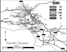
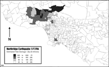
These maps show EQE estimates of Modified Mercalli Intensities (MMIs) and expected damage in the affected zip codes.
Disaster Aid
The California Office of Emergency Services retained EQE to assist the State with its application and administration of disaster aid by producing an immediate estimate of the total damage. The day of the earthquake, EQE used its EQEHAZARD software to produce a projected map of the affected zip codes, as well as initial damage estimates for residential, commercial, industrial, and public property. The damage to the supporting infrastructure (transportation, water, power, telecommunications) was also estimated. The $15 billion total damage estimate became the basis for the Governor’s appeal to the President and Congress for aid to California. The resulting map was also used to allocate resources in the affected area. To our knowledge, this was the first use of this technology to improve overall disaster response.
Return to Northridge Summary Report 1994 Contents page.