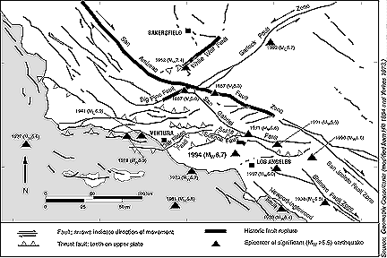
Major active faults and epicenters of significant historical earthquakes in Southern California.
Geologic Setting
The San Fernando Valley is broadly elliptical, about 30 km long on its east-west axis and 16 km wide. It is bounded on the northeast by the Verdugo Mountains and the western San Gabriel Mountains, on the northwest by the Simi Hills and the Santa Susana Mountains, and on the south by the Santa Monica Mountains. The mountains have an east-west trend, which is consistent with being part of the Transverse Ranges. The ranges are actively deforming by folding and thrust-faulting in response to the north-south-directed compression that is occurring across the “big bend” region of the San Andreas Fault (where the fault abruptly takes a more northern course).
The San Fernando Valley is underlain by a thick fill of alluvium. This alluvium is underlain by thousands of meters of sediments, mostly of marine origin, which were deposited upon granitic and metamorphic basement rocks.
Seismology
Reports from the California Institute of Technology and the U.S. Geological Survey indicate that the epicenter of the Mw 6.7 main shock occurred at a depth of approximately 18 km. The main shock’s focal mechanism and associated aftershocks indicate that thrusting occurred along a plane that dips 35o to 45o to the south-southwest. This is the opposite of the direction of thrusting from the 1971 San Fernando Earthquake.
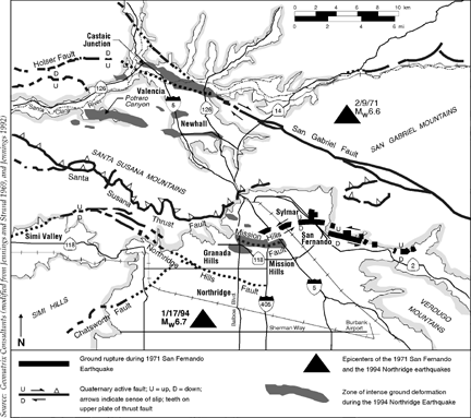
Active faults, ground rupture of the 1971 San Fernando Earthquake, and regions of ground breakage during the 1994 Northridge Earthquake in the northern San Fernando and western Santa Clarita valleys.
Aftershock activity was high; there were 13 aftershocks of magnitude greater than or equal to 4.0 between January 18 and 28. Although the level of aftershock activity had been high, the aftershock frequency decay was consistent with other larger California earthquakes. The pattern of aftershocks indicated that rupture occurred on a south-dipping plane at depths between approximately 5 and 18 km. Above 5 km, the seismicity pattern was more diffuse, possibly due to activity along one or more north-dipping backthrusts.
Northward directivity of energy was indicated by strong-motion recordings north of the event. As a result of slip on the causative fault, the San Fernando Valley may have moved north a few centimeters, closer to the city of Bakersfield.
Surface Deformation
Several east-west-trending zones of ground rupture have been identified. One is located near the northern margin of the San Fernando Valley through Granada Hills, and at least three other zones are located on the northern flank of the Santa Susana Mountains near the towns of Newhall and Castaic Junction, about 24 km north of the epicenter in Northridge.

Slope failure at the Joseph Jensen Filtration Plant near Sylmar.
Ground breakage in the Granada Hills area consisted of both compressional and extensional fracturing in a linear east-west-trending zone that extended for about 4.5 km. The overall north-south width of the zone was between 0.5 and 1.3 km.
Extensive damage to underground utilities was associated with this zone, including the rupture of a gas pipeline and a water main (see section on “Gas”). Fires associated with the ruptured gas main burned five houses and damaged several more. The eastward extension of this zone was roughly aligned with another water main rupture and with damage at Southern California Edison’s Rinaldi Substation below the lower San Fernando Reservoir.
Many houses in this area straddled this minor fault-like feature and had light to moderate damage from ground breaks, particularly to their foundations. Overall, the damage from shaking to single-family houses, mostly one and two stories, in this area was not noticeably different from damage in the general epicentral area 6 km to the southwest. This indicated that the shaking intensities in the two areas were comparable.
North of the Santa Susana Mountains in the Santa Clarita Valley region, at least three subparallel zones of ground disturbance were observed. Ground cracks were observed in Potrero Canyon and in Salt Canyon, a smaller canyon to the south. This zone of intense ground fracturing aligns with a zone of damage that passes through the nearby town of Newhall to the southeast. A second west-northwest-trending zone about 8 km long extends from near a school north of Newhall to near Castaic Junction. A third linear zone of damage extends from Valencia northwest to a U.S. postal facility southwest of Castaic Junction.
Ground disturbance, such as damaged pavement, sidewalks, and curbs, was identified along a west-northwest-trending zone about 1 km wide and 8 km long from near a Valencia sewage treatment plant to west of Castaic Junction. Extensive building damage, sewer line ruptures, and high-voltage electrical tower damage occurred along this zone. This zone of ground disturbance and another zone nearby are roughly parallel to the trend of the mapped San Gabriel and Holser faults.
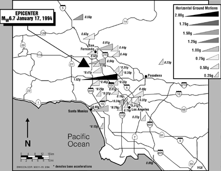
Peak horizontal accelerations at ground level. Recording sites are at the left-hand point of the triangle. The strongest accelerations are located in a narrow band running north-south near the epicenter. There were no instruments west of the epicentral area.
Results of the initial reconnaissance were somewhat ambiguous with respect to the association between the identified zones of ground breakage and the fault rupture at depth. Unlike the 1971 San Fernando Earthquake, the Northridge Earthquake did not produce obvious fault ruptures at the surface. At the time of this writing, it was not yet clear that any of the mapped zones of ground breakage represented surficial faulting associated with slip on the causative fault. In this respect, the Northridge Earthquake is similar to the 1989 Mw 6.9 (surface wave magnitude 7.1) Loma Prieta Earthquake.
Causes of Damage
Damage to engineered structures during the Northridge Earthquake can be attributed mostly to earthquake-induced ground shaking; however, liquefaction, lateral spreading, differential compaction, landslides, and possible surface faulting also contributed to the damage. Post-earthquake fires also caused damage (see section on “Fire Following Earthquake”).

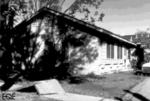
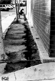
Pavement cracking caused by ground failures (and possible faulting) in a Granada Hills cul-de-sac.
Ground Shaking
Near-record strong ground motions were generated by the Northridge Earthquake. Recorded peak horizontal accelerations at the ground surface, at sites located within about 10 km of the earthquake rupture surface, ranged between 0.3g and 1.2g. These record-high ground motions within a metropolitan area caused severe structural damage within the San Fernando Valley. Most concentrated damage located outside the epicentral region appeared to be within areas of deep alluvial deposits, at valley margins, or on steep slopes and ridge crests. Ground motion amplification at many of these sites contributed to the heavy damage in these areas. With the exception of two strong-motion stations, recorded peak horizontal accelerations at sites from about 20 to 50 km away from the rupture zone ranged from 0.1g to 0.6g. The anomalies were peak horizontal ground accelerations of 1.0g and 1.8g recorded at Tarzana, about 16 km from the rupture zone, and 0.9g at Santa Monica, at a distance of about 30 km. The duration of strong motion was typically about 15 seconds.
Strong-ground-motion records were obtained by the California Division of Mines and Geology, the U.S. Geological Survey, the University of Southern California, and others from instruments distributed throughout the Los Angeles Basin. The recorded horizontal peak ground accelerations were compared with predicted motions for an Mw 6.7 thrust-fault earthquake, based on attenuation relationships (developed by Geomatrix Consultants in 1986 and 1993, and by EQE’s Kenneth Campbell and Yousef Bozorgnia in 1994) for rock and soil conditions. Recordings, especially on deep and shallow soil sites, appeared to follow a trend that was about 1 standard deviation above the median prediction. Ground motions recorded on soil sites during the Northridge Earthquake were also consistently higher than those recorded during the 1971 San Fernando Earthquake. High peak vertical accelerations were recorded in the epicentral region, and the available data suggested that the relationship between vertical and horizontal ground motions was consistent with observations made in other earthquakes.
-
Left: A buckled sidewalk and cracked foundation in Granada Hills caused by possible faulting.
Right: Ground fissures at the San Fernando Juvenile Hall.
Typically, the north-south motion was much stronger than the east-west motion. Some of the affected area had ground motions that were more than twice those contained in the building codes. Vertical motion, typically assumed at about two-thirds of the horizontal, was also very strong and caused large additional forces on buildings already heavily loaded in the horizontal direction.
These high recorded accelerations from a moderate-magnitude event suggest that a thorough reevaluation of ground-motion assumptions used for design purposes is needed, particularly for thrust-type earthquakes.
Soil Liquefaction and Lateral Spreading
Evidence of ground failures caused by soil liquefaction and lateral spreading was observed throughout the epicentral region and as far as 50 km from the epicenter. Overall, liquefaction effects and associated lateral spreading were not a major cause of structural damage when compared with that caused by shaking.
At the Joseph Jensen Filtration Plant near Sylmar, which was under construction and extensively damaged during the 1971 earthquake, ground failures are believed to be related to liquefaction of loose alluvial soils underlying a 12-m-high embankment fill. These ground failures were probably responsible for damage to the water intake line to the plant, as discussed in the section on “Water and Wastewater.” Liquefaction also caused about 15 cm of settlement and extensive pavement cracking in the parking lot at the plant.
At both the filtration plant and the nearby San Fernando Juvenile Hall, ground failures produced by the Northridge Earthquake were significantly less severe than those from the 1971 San Fernando Earthquake, but they occurred at the same locations.
In the yacht club at King Harbor in Redondo Beach, liquefaction of sand fill resulted in settlement distortions of two buildings and large lateral spreading movements that severely damaged a concrete retaining wall and several mooring pylons. At the swimming lagoon, a long diving platform and a concession building also settled differentially. The King Harbor area, which was developed during the early 1960s, reportedly did not have liquefaction effects during the 1971 San Fernando Earthquake.
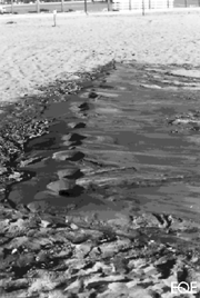
Sand boils at a city swimming lagoon in King Harbor.
Landslides and Slope Movements
Landslides and rockfalls triggered by the earthquake were common on steep slopes surrounding the epicentral region. Failure of the coastal terrace at Pacific Palisades damaged several homes and temporarily blocked the Pacific Coast Highway (State Highway 1). Numerous slope failures occurred along steep slopes and shattered ridge crests in the Santa Susana Mountains, particularly along their northern flank.
In the Granada Hills area, a portion of an apartment building in a hillside condominium development collapsed because of foundation movements in an area that appeared to have had downslope movement prior to the earthquake. In the Valencia area, located about 20 km north of the epicenter, damage was observed in two hillside developments in three-story apartment buildings and single-family wood-frame houses that were constructed on fills.
References for Map Information
Hill, M. L. 1954. “Tectonics of Faulting in Southern California.” California Division of Mines and Geology Bulletin, No. 170: 5-14.
Jennings, C. W. 1992. Preliminary Fault Activity Map of California. DMG Open File Report 92-003. California Department of Conservation.
Jennings, C. W., and R. G. Strand. 1969. Geologic Map of California - Los Angeles Sheet. Scale 1:250,000. California Division of Mines and Geology.
Yerkes, R. F. 1973. “Effects of San Fernando Earthquake as Related to Geology.” In San Fernando Earthquake of February 9, 1971, Vol. 3. Edited by N. A. Benfer, J. L. Coffman, and J. R. Bernick. Washington, D.C.: National Oceanic and Atmospheric Administration, U.S. Department of Commerce.